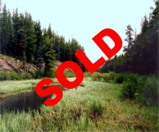
Maxwell Creek Ranch
| Listing Number: | Cariboo 9-12 |
|---|---|
| Size: | DL 12297 – 160 Acres Total: 795 Acres |
| Map Reference: | 93B12 |
| Price: | SOLD |
| Legal: |
|
| Description: | The four properties combined are about ¼ mile wide and slightly under four miles long, with Maxwell Creek running through the centre. They are unique in that they are completely surrounded by crown land on all sides making it a very private setting. These lots lie in a valley at the base of a small mountain and are very private, well hidden and secluded. Cattle graze throughout the summer months on this property and there is also a large population of moose in this area. Every time we have visited this property we have seen at least one or two moose on the meadows. The meadows here connect with other meadows on crown land and a person can ride a horse for miles. Just half a mile north of the northern boundary of this ranch is two log cabins and some corrals, in a field beside the creek. DL 12297 – approximately 129 acres of this 160 acres parcel are meadows and the remaining acreage is covered with lodge pole pine. There is a 4,500 feet airstrip located in the northeast corner of the property. At present approximately 600 meters (1969 feet) of the airstrip has been cleared and useable. Half of the airstrip is on this land and half runs into crown land to the north. This airstrip would give quick access by plane to and from Vancouver. This lot is mostly level with a slight slope to the north enhancing the view of the meadow to the south. There is an old road running along the entire west boundary cutting through the north end to some old log cabins and corrals a few hundred yards to the east. D.L. 9149 – Lodge pole pine covers approximately 18 acres of this property, the rest being meadow. A large, two bedroom cabin approximately 30’ x 45’ (well constructed on a cement foundation and with a metal roof) sits beside the creek near the north boundary with a beautiful view overlooking the large meadow to the south and the surrounding hills. Underneath the cabin there is a large crawl space for storing There is an old road running west from the cabin, and a second road continues north to some old log cabins and corrals on crown land. Maxwell Creek runs through the centre of the property from the south end, flowing north. D.L. 12251 – Approximately 40 acres of this 345-acre property are covered with lodge pole pine while the remainder is rolling meadow. It is a very unique parcel of land sitting in a valley with rolling hills to either side. Maxwell Creek runs through the centre, from the south to the north. This property is flat except for a few ridges overlooking the meadow. An old road, which for the last part is only A.T.V. access, runs to the centre of this property. D.L. 12298 – Approximately 114 acres of meadow and 16 acres of lodge pole pine make up this parcel of land. It is located in a small valley. An old driveable road runs close to the south boundary of this property. |
| Location: | This ranch is located on the Chilcotin Plateau, northwest of Alexis Creek, which is 113 km west of Williams Lake on Highway #20 in west central British Columbia. |
| Access: | There are two accesses that are both very well hidden to this property, making the ranch very private. Both these roads give access to the north end of the property. These roads were not improved, providing a very private setting. 1. To reach property by truck – From Williams Lake go west on Highway 20 for 112 kilometers (70 miles) to Alexis Creek. Continue past Alexis Creek for 33 kilometers (21 miles) and just before the Chilcotin River Bridge turn right onto the (gravel) Chezecut Forestry Road. Stay on the main road for 51 kilometers (32 miles) and just past 147 km sign take the second road on the right. It is marked by a variety of coloured flagging tapes, drive up a hill through a logged area and follow this main road. The road is marked by yellow ribbons at most main junctions. At approximately 12 km there is a fork stay right, 500-600 meters after you will see some buck fencing and an old gate turn left here. Approximately 4 km later there is another fork, keep right and stay on main road for 9 km to the ranch house. To get to the middle and south end of the property, instead of turning left on the road with the pine pole buck fencing, continue straight on the logging road. You will go through two logged areas and a few hundred feet past the second logged area turn right on an old road marked with some orange ribbon. At approximately 1km there is a 3-way junction; turn right and you can drive to the south end. If you turn left you can drive only part way and then walk to the centre of the property. 2. To reach property by car and A.T.V. – From Williams Lake travel west on Highway 20 for 112 km to Alexis Creek follow Highway 20 for 10 km and turn right at the sign heading to Alexis Lakes. Just past 32 km marker there is a junction, bear left onto the Clusko Aneko Forestry Road. Continue just past 55 km marker to the junction for Clusko-Tzazti Forest Service Road. From this junction, on the Clusko Aneko Forestry Road follow the sign markers for approximately 27 kilometers and just a few hundred yards before the 82 km sign you’ll be in a logged area, you will see some stones used as a fire pit, from here a well hidden all-terrain vehicle trail leaves the road to the left and cuts through the logged area, into the pine forest. This trail will cross the creek where we have built a small bridge and pass two old cabins, which are not on the property. Follow the road from these cabins south and about half a mile you’ll be on the property. You will see the two-bedroom cabin overlooking the meadow. |
| Recreation: | Camping, boating and RV accommodation are available near Alexis Creek. Bull Canyon Provincial Scenic Spot is 9 km (5.6 miles) west of Alexis Creek and offers campsites by the Chilcotin River in a setting of sheer rocks and caves. Numerous lakes in the area offer fishing for rainbow trout and Dolly Varden. Abundant moose and deer are found throughout this area. |
| Services: | None |
| Area Data: | The Chilcotin Plateau is well known for its open grasslands with spectacular views of snow-capped mountains in the distance. The area where this ranch is located is quite unique and very private – in a small valley at the foothills of the mountains. Next to the Merritt area, the Chilcotin area hosts some of the largest ranches in British Columbia. There are a number of guest ranches and resorts off the main highway and throughout this area. |
| History: | The previous owners told us that this land was originally ranched, and ran about 400 head of cattle. A Hudson’s Bay Company trading post was established as early as 1828 at the confluence of the Chilco and Chilcotin Rivers near Alexis Creek. Native peoples then concentrated more on furs, in order to trade for guns, blankets, and rice. The routes they traveled became known are “grease trails”. The first cattle ranchers came in the 1860’s and small communities began. Alexis Creek was named after Chief Alexis, a leader of the Chilcotin Indians. Maxwell Creek was named for Chauncy Maxwell who came into the area in 1912 and pre-empted land twenty miles north of Chezacut. In 1916 Maxwell married and purchased the Sherringham Ranch at Chezacut. He raised three sons and died in 1934. |
| Vegetation: | Approximately eighty percent of the lots are hay meadows, with the remainder in pine forest, with approximately 3,000 m3 or more of timber. |
| Zoning: | All four of the properties are zoned RR1, Rural Resource and are not in the A.L.R. |


